Water Resources Engineering
Design of a New Lake Outfall
Hydrologic and Hydraulic Modelling
Hydrologic and Hydraulic Modelling

Riggs was retained to complete the marine design component of a sewer outfall. The tasks included characterizing the coastal environment, carrying out dispersion modeling and design calculations, marine surveys (soundings, side-scan sonar, and underwater video recording), and the design of an optimum configuration of the outfall diffuser. All field investigations were undertaken using in-house equipment including a Trimble GPS, RESON echo sounder and Imagenex sidescan sonar.
Detailed plans and specifications were prepared for all in-water components of the work. The diffuser design took into consideration concerns related to ice damage and on-going maintenance. A detailed design was undertaken to identify the most appropriate lake bed scour protection, pipe and protective rock placement, and installation of reinforced concrete pipeline anchors.
Hydrologic and Hydraulic Modelling
Hydrologic and Hydraulic Modelling
Hydrologic and Hydraulic Modelling

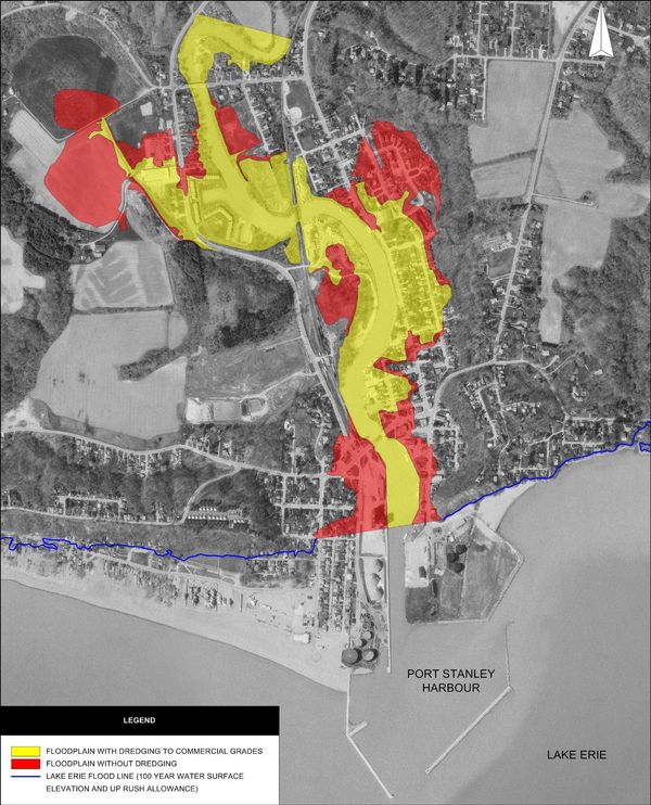
Riggs has recently completed a hydrotechnical study on behalf of the Kettle Creek Conservation Authority. As part of the study, a hydrologic model of the Kettle Creek watershed was developed. The objective of the hydrologic modeling was to quantify the response of the watershed to high intensity short duration storm events. The model was calibrated and verified using existing data. Following calibration, precipitation inputs were prepared to simulate a regulatory storm event. Flows obtained from the hydrologic model were subsequently used to delineate the extent of flooding.
Hydraulic modelling within the town of Port Stanley was carried out to establish flood lines for a number of different scenarios related to harbour dredging. It was established that different harbour configurations (dredged to full draft, dredged to recreational draft, or fully silted) could produce markedly different upstream flooding impacts. The scenarios of our study were presented both to the conservation authority and municipal officials, as well as to local interested residents.
Riggs Associates Ltd.
205-1240 Commissioners Road West, London, Ontario N6K 1C1, Canada
Phone: 519-657-1040
Copyright © 2022 Riggs Associates Ltd. - All Rights Reserved.